 |
| The Tetons on a cloudy, beautiful July day. |
First I would like to say that if you are considering taking a trip to Grand Teton National Park... GO! It.. is... amazing. From the moment you enter Wyoming (if driving), there are non-stop views of wide open plains and rolling hills full of sagebrush. That is, until you hit the Rockies. The Tetons (no, not the "Grand Tetons". There can only be one...) stand in stark contrast to their surroundings. Rising sharply out of the ground, they hold some of the oldest rock in the Rocky Mountain range. Now, before I start to sound like a Wikipedia page (though you should really go check out the geologic history of GTNP), I'll get on to the important stuff: how to visit and some of the lessons learned during the trip. I'll be writing this from a perspective that you, the reader, understands that visiting the backcountry in any national park is a privilege and, as such, should be conducted with care. Know the "Leave No Trace" principles, know how to store food (bear canisters are available for free with backcountry permit!), know how to use compass and map, and know that you are physically capable of the trip you are planning.
 |
| A good view of Death Canyon Shelf and the Tetons in the distance. |
GTNP is possibly the most beautiful national park in the country. It's also, in my opinion, one of the easiest to visit. It's accessible and cheap, when done right. I went to the Tetons last year with two friends (Trevor and Zach). For our trip, we planned six days in the backcountry with two nights before the start of backpacking to get things in order (It's necessary. I'll cover this in just a bit...). Instead of obtaining our permits early through Recreation.gov, we decided to get walk-up permits, which are available the morning before you plan to start your backcountry trip (if you plan to start your trip Monday morning, the earliest you could get your walk-up permit is Sunday morning. First come, first served.), so get there a little before the visitor center opens (we went to the Craig Thomas Visitor Center) to get your backcountry permit. Be sure to have your itinerary planned out! If you have any questions, the staff inside the center are more than willing to help you. All of the camping zone maps and information can be obtained from the GTNP federal website. I will not be telling you what my itinerary was on this blog! Why?? Because go plan your own backcountry adventure and LOVE EVERY SECOND OF IT that's why :)
Feel free to email me if you have specific questions about planning your own trip. I'd love to help!
 |
| Schoolroom Glacier and the tarn at the bottom, North Fork Cascade Canyon. Me (left) and Trevor (right). |
Now, for your first two nights before you head out on your trip you could reserve a campsite near Jenny Lake or some other location, which will be inside the park, at the base of the mountains, have fairly stellar views, and will cost you a couple $$ for park entrance and camping fees. OR... you could stay in the adjacent Bridger-Teton National Forest for free, find your own campsite on Shadow Mountain, and have perfect views of the Tetons.
 |
| A fiery sunset viewed from Shadow Mountain. |
This is what we did for our first two nights and it was honestly one of the highlights of our trip, as we saw the best sunset in the world on our first night. Being in the mountains is amazing in its own way, but there is also something special about camping outside the range, in full view of the peaks, soaking in the surroundings.
 |
| Our campsite on Shadow Mountain before the trip. |
I could give you a list of the amount of elevation or miles we covered each day, GPS waypoints of our campsites, or any other information I obtained while researching for this trip, but I would rather YOU do the research and make it your own adventure. This post is not meant to be a step-by-step guide to visiting the Tetons. Rather, it's meant to inspire you to do it for yourself and cherish the reward of exploring the backcountry.
 |
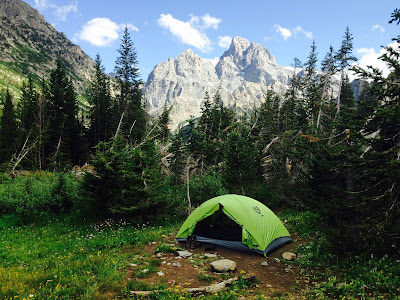
| My campsite with the Grand in the background, North Fork Cascade Canyon. |
I learned a ton while planning for this trip and it would not have been possible without key information from Michael Lanza's website The Big Outside, the national park website and maps found there, as well as a few other blogs I stumbled across.
 |
| Zach (left) and Trevor (right) crossing the Targhee National Forest boundary. |
The information is out there to plan the best trip of your life in one of America's most pristine locations. Just get out and do it!
 |
| The three of us hitching back to our car at the end of the trip. What an adventure! |
No comments:
Post a Comment